
What Is A Typhoon?
A Typhoon is an intense area of low atmospheric pressure. Like all low pressure weather systems observed North of the Equator, the air rotates around the center of an area of low pressure in an anti-clockwise direction (clockwise if South of the Equator). The more intense the area of low pressure the higher the wind speeds near the center. A Typhoon is a low pressure weather system with sustained wind speeds near its center of at least 56 knots (about 105 kph).
What Makes A Typhoon?
Typhoons are made over the ocean; typhoons are not made over land.
To make a Typhoon you need a lot of warm, moist air evaporating off the ocean surface and rising rapidly, creating the area of relatively low pressure - a weather system. The rapid rising of the air mass and the subsequent condensation of the moisture at altitude, combined with the rotation of the Earth, are the necessary energy components to facilitate rotation of the weather system; a Tropical Depression (TD) is formed. When the upper atmospheric conditions are conducive then the rotation is accelerated and the weather feature forms into a Tropical Storm (TS). Assuming the Tropical Storm remains over an area of warm ocean - with a sea surface temperature above 26 degrees Celsius - then the weather system will most likely continue to increase in rotation speed until it reaches the status of a typhoon – sustained wind speeds in excess of 56 knots near its center. If the sea surface temperature is less than 26 degrees Celsius then a typhoon has insufficient energy and cannot sustain itself; if the sea surface temperature is greater than 32 degrees Celsius then the weather system may become overpowered and may dissipate, but this does not always happen.
Where Are Typhoons Made?
In the northern hemisphere of the planet, Tropical Depressions can form anywhere in the tropical region (5 - 22 degrees latitude). where the sea surface temperature is above 26 degrees Celsius; only rarely do Tropical Depressions form close to the equator (0 - 5 degrees latitude). Tropical Depressions tend to move haphazardly until they reach Tropical Storm status, at which point they tend to move in a westerly or northwesterly direction. A Typhoon will almost always move northwest until it reaches the subtropical zone (18 - 25 degrees latitude) when it will usually turn North and then finally northeast before dissipating over cooler water.
Typhoons with sustained wind speeds in excess of 115 knots (about 200 kph) are frequently referred to as Super Typhoons, equivalent to a category 4 storm in the Atlantic; a Super Typhoon can have wind speeds near its center in excess of 150 knots, these are becoming more frequent.
With Man-induced climate change now apparently unstoppable, the associated increase in sea surface temperature is also creating stronger storms, more frequently. On 6th November 2013, Typhoon Haiyan (Philippine name Yolanda) made the record books as the strongest storm ever to make landfall anywhere around the planet, as it smashed into the town of Guiuan, on the southeast corner of Samar, Philippines, with wind gusts in excess of 200 knots (370 kph) . . . it also generated a storm surge of (estimated) 7 metres high.
What Affects A Typhoon Track?
The main factor affecting the track of a Typhoon is its proximity to, and intensity of, an anti-cyclone (area of high pressure); anti-cyclones most frequently occur North of the sub-tropical region (above 25 degrees latitude) over a large landmass, such as Siberia, or sometimes over the North Pacific. If the anti-cyclone is intense then the Typhoon will tend to track with a more westerly vector and increase in wind speed more rapidly.
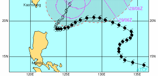
Typhoons tend to follow the barometric contours of an anti-cyclone until they reach 25 degrees latitude, when they will usually start to dissipate. However, Typhoons have been observed to move erratically and their paths are sometimes difficult to predict – Typhoon Gerald (1987) is a classic example of a Typhoon with an unpredictable path, as it performed crazy-eights in the West Philippine Sea and South China Sea, south of Hong Kong, before finally dissipating over land in South East China. More recently, Typhoon Lupit (22W) in 2009, made like a snake as it approached the Philippines, before finally turning North (see below image of Typhoon Lupit’s track).
When a Typhoon crosses a land mass it will lose power because: (a) the air mass will be forced higher and start to cool; and, (b) it will no longer have access to its fuel – warm, moist air rising off the ocean. A Typhoon crossing the high mountains of northern Luzon, for example, may lose as much as 50% of its power during the short, one hundred mile transit.
A Tropical Depression or Tropical Storm passing over land will typically deliver higher levels of precipitation than a fully formed Typhoon.
Typhoon, Cyclone & Hurricane
A “typhoon” is the term used to describe the same weather feature as a “cyclone” or a “hurricane”: the term Typhoon is used for intense low pressure weather systems in the northwest Pacific; the term Cyclone is used when referring to an intense low pressure weather system over the Indian Ocean and the South Pacific; and, the term Hurricane is used when referring to an intense low pressure weather system over the Atlantic Ocean and East Pacific.
Of interest, only one Hurricane has ever been recorded over the South Atlantic (March 2004), although weather systems that developed in the South Atlantic during March 2010 and March 2011 were classified as tropical cyclones for a few days each before dissipating. Some suggest that the fact that these weather systems have been recorded only within this century is additional evidence of Man-induced climate change - no credible alternative explanation has been accepted.
Typhoon Measurement, Strength & Scaling
In the 21st century Typhoons are measured using the Saffir-Simpson scale, which has five Categories. Category 1 refers to a storm (Typhoon/Hurricane/Cyclone) with sustained wind speeds of between 119 and 153 Km/h. By contrast, a Category 5 storm has sustained wind speeds in excess of 252 Km/h.
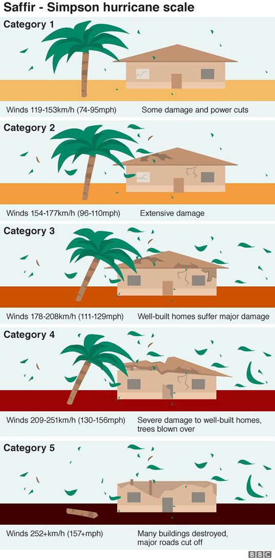
image courtesy BBC
Prior to the 21st century Category 5 storms were infrequent - an average of three per season. In the current century there have been an average of five or more per season, and the frequency is increasing. The increase in frequency is traced to the warming of the oceans, which increases evaporation of moisture laden air – the fuel required by tropical storms. The warmer oceans are due to the inability of the increasingly warmer blanket of air above to dissipate the heat energy absorbed by the ocean from our sun. The warmer blanket of air is in turn due to increased volumes of greenhouse gases in the atmosphere.
If we want to reduce the number of Category 5 storms, and the destruction that they deliver to coastal, tropical communities and ecologically important habitats, then we must cool the blanket of air above the oceans. To cool the blanket of air above the oceans we must reduce the volume of greenhouse gases in the atmosphere. We MUST stop burning fossil fuels and we MUST stop producing HFCs and instead use refrigerants based on ammonia and, ironically, CO2 or even HFOs.
Typhoon Names & Numbers
All intense low pressure weather systems are given numbers, sequential within the current year, e.g. Typhoon 20W (20th typhoon this year in the West Pacific). They are given names once they become established tropical storms with the potential to become Typhoons e.g. Typhoon (Nesat) 20W; these are the names by which specific Typhoons will become known internationally. Historically, Typhoon names alternated between anglicized male and female names (interestingly, Typhoons with women’s names were most frequently the most powerful and destructive) but at the turn of the century a list of largely genderless Asian names was chosen, from which individual typhoon names are used in rotation. Some countries, notably the Philippines, have their own, additional naming scheme for typhoons, which leads to some confusion in news reporting, e.g. Typhoon “Nesat” (2011) was called “Pedring” in the Philippines. In the last century the northwest Pacific was expected to spawn an average of 25 named Typhoons during a year but this average has increased in recent decades.
The word “typhoon” most probably originates from the ancient Greek language, where it referred to a weather related, mythological monster. In Cantonese/Chinese “typhoon” translates (phonetically) directly to “big wind”.
back to Philippine Weather
Can't find what you are looking for here? Email: webmaster (at) pgyc.org
Copyright © 2003–2024 Puerto Galera Yacht Club, Inc., Philippines; All Rights Reserved
All Images and Text on this page are covered by Copyright and are not considered Public Domain; contact the webmaster(at)pgyc(dot)org to request permission to resuse an Image and or Text on this page
Disclaimer