


Tsunami and earthquakes can happen anytime around the Pacific Ring of Fire - from California up and around Alaska down through Japan, Taiwan, the Philippines and Indonesia. The Philippines is no stranger to earthquakes - the Philippine archipelago was largely created by the tectonic squabble between the Eurasian and Pacific plates, forming the Philippine Plate as a distinct entity.
In the Philippines an earthquake is known as a "lindol".
Earthquake Philippines Today
Latest Philippines Earthquake 27-Jul-2026
click the image for earthquakes today

The above image is linked to the U.S. Geological Survey (USGS) website - click the image
Latest earthquake activity near Metro Manila: 5 December 2023, magnitude 5.7, at 16:23:55 local (GMT+8), location 13.930°N 120.462°E approximately 30km SW of Nasugbu, Batangas, depth 78KM, felt in Metro Manila as magnitude 3.0; minor but sharp movement for people living in high-rise buildings for about 70 seconds. Full details: earthquake info from USGS website.
The majority of Philippine earthquakes occur somewhere near the Philippines' Pacific East coast (especially the East coasts of Mindanao & Samar), where a significant tectonic subduction zone has created the second deepest ocean trench in the World - named the Philippine Deep or the Philippine Trench - with a depth greater than 34,000 feet! On 31st August, 2012, this area of the Philippines received a 7.6 magnitude earthquake along the Philippine Trench, East of Samar Island.
Having said that the fault line that passes down the West coast of Luzon and turns into the Verde Island Passage delivers frequent tremors to Luzon and Mindoro. These tremors frequently cause minor earth movements around Puerto Galera.
Just as in California, U.S.A., a measurable earthquake in the Philippines (greater than Magnitude 2.5) occurs almost every day somewhere, but most people are completely unaware of them. It is rare to have an earthquake in the Philippines that measures greater than Magnitude 6.0.
The last significantly destructive earthquake in the Philippines occurred on 15th October, 2013, beneath the West coast of Bohol Island. The Bohol earthquake was measured as Magnitude 7.2 causing substantial damage across the island, and cited as the cause of 222 fatalities. Damage was apparent to buildings in the provinces of Bohol and Cebu.
Remember: earthquakes do not kill - buildings kill; explore the Philippines' beautiful beaches, rivers, mountains and rain forests, instead of its cities.
The Marikina Fault
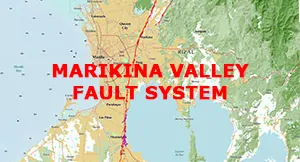 If you live in the National Capitol Region you should be interested. Tap image to read more . . .
The most significant, historic earthquake zone (geological fault) in the Philippines is located just 10km East of Manila City and is known as the "Marikina Valley Fault".
Historic Philippine Earthquake Information
For detailed historic Philippine earthquake / seismic event information plus: seismic events / earthquakes during the past seven days, including earthquake maps, earthquake graphics and related technical data, we recommend: U.S. Geological Survey Earthquake Hazards Program
Tsunami Philippines
Tsunami in the Philippines are extremely rare.
The last measurable tsunami in the Philippines affected the northern and the eastern seaboards on 11th March, 2011. In that event, tsunami waves of around half a meter, resulting from a relatively shallow and very large 8.9 magnitude earthquake off the coast off Miyagi prefecture, Honshu, Japan, arrived in the early evening and caused little or no damage, and no loss of life.
Prior to March 2011, the last recorded tsunami in the Philippines, that actually caused loss of life, occurred in the Verde Island Passage (between Batangas & Mindoro Island, affecting Puerto Galera) in the early morning of 15th November 1994, originating from a 7.1 magnitude (Moment Magnitude Scale) earthquake, 11 KM West of the Baco Islands, according to the Philippine Institute of Volcanology and Seismology. The tsunami waves, resulting from the 7.1 magnitude earthquake, were measured at 6 meters in many areas when they reached land, but up to 8.5 meters in a few locations (primarily the Baco islands) where the bathymetry was favorable; the tsunami waves reached up to 250 meters inland in areas that faced the earthquake epicenter. The death toll was 41 people.
Tsunami Warnings
For current and recent tsunami warnings: U.S. National Weather Service U.S. Tsunami Warning System
Can't find what you are looking for here? Email: webmaster (at) pgyc.org
Copyright © 2003–2026 Puerto Galera Yacht Club, Inc., Philippines; All Rights Reserved
All Images and Text on this page are covered by Copyright and are not considered Public Domain; contact the webmaster(at)pgyc(dot)org to request permission to resuse an Image and or Text on this page
Disclaimer Privacy Policy